event

Connecting with the open-source community at FOSS4G Belgium

FOSS4G Belgium took place on 15 October at Bruxelles Environnement site in Brussels, a sustainable, low-energy building showcasing excellent environmental architecture. As proudly featured on the event lineup, we were thrilled to participate as Bronze Sponsors for this year’s gathering of the Belgian open-source geospatial community.

It was an event-filled day for our team. Tomas Mizera and Gabriel Bolbotina represented us on stage, leading sessions, engaging with users, and taking part in community-wide discussions throughout the day.

Our talks and workshop

Collaborative data collection with QGIS & Mergin Maps

Tomas gave a talk in the Sylva room highlighting what’s new in collaborative data collection using QGIS and Mergin Maps. He walked attendees through recent platform improvements, seamless sync enhancements, and real-world workflows that help field teams collaborate efficiently across desktop and mobile.

Building a mobile GIS that works offline and syncs reliably

During the flash talk sessions in the Agora room, Gabriel shared insights into the engineering challenges of building a mobile GIS application. He focused on ensuring reliable offline data synchronization, robust local storage, and conflict resolution mechanisms for field teams operating in remote areas with poor connectivity.
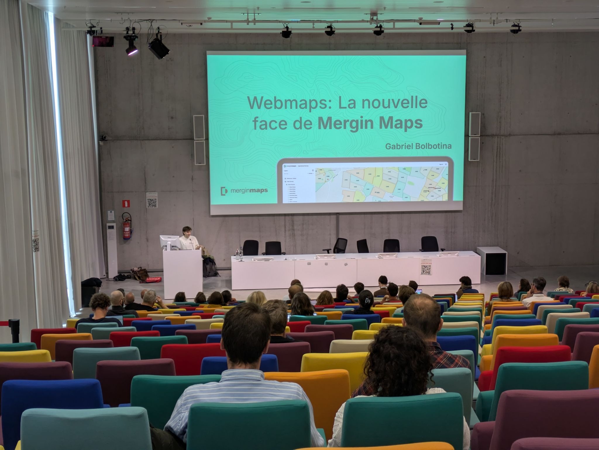
Our workshop

In the afternoon, Tomas ran a hands-on, 90-minute workshop titled From field to map: Collaborative data collection with QGIS & Mergin Maps in the Aqua Workshop room.

The session was fully booked well in advance. Participants went through a complete end-to-end workflow: configuring project layers and custom forms in QGIS, packaging projects for mobile deployment, collecting field data on devices via the Mergin Maps app, and synchronizing spatial updates back to the cloud in real time.
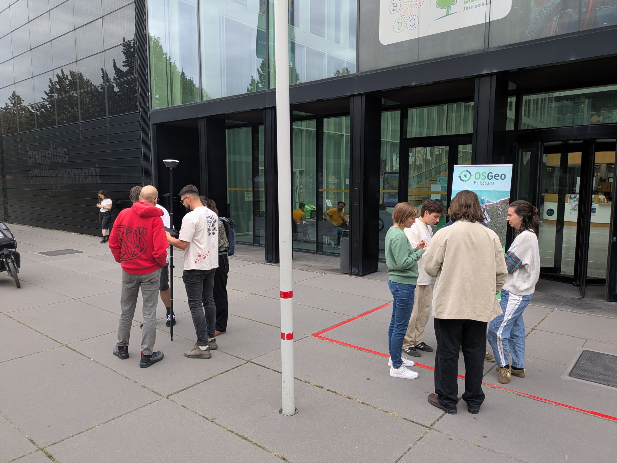
Workshop participants collecting field data

Customer feedback & community inspiration

Between sessions, our stand and the venue corridors were buzzing with activity. One of our highlights of FOSS4G Belgium was reconnecting with existing customers and meeting new QGIS users.

Hearing directly from field managers, GIS specialists, and developers about how Mergin Maps fits into their daily workflows gave us valuable feedback and fresh ideas for upcoming release cycles. The energy of the local Belgian community from government representatives to independent consultants left us inspired for what’s ahead.

No event in Brussels would be complete without enjoying local Belgian beer culture! We had a fantastic time unwinding and continuing discussions during the evening social networking event. Sharing a few drinks with fellow OSGeo enthusiasts, partners, and users was the perfect way to wrap up an intensive day of tech talks and workshops.

Thank you

A huge thank you to the organizers at OSGeo.be, Bruxelles Environnement, the volunteers, and our fellow sponsors for hosting a smooth and well-run event. Special thanks to everyone who attended our talk, joined the workshop, or stopped by to chat.

If you’d like to learn more about anything we presented or explore how Mergin Maps can streamline your field data workflows, feel free to get in touch. See you at the next FOSS4G!

‍

You might also like

Mergin Maps

Mergin Maps best practices: From setup to fieldwork

September 16, 2026

Mergin Maps

A new direct way to connect Trimble receivers

September 3, 2026

Mergin Maps

Take your QGIS projects to the web: Now with map themes and JS customizations

August 27, 2026

Mergin Maps

Connect external GPS receivers via network (TCP/UDP)

July 27, 2026

Mergin Maps

Introducing early access: one-click OGC API support 

June 30, 2026

other

Best alternatives to ESRI ArcGIS Field Maps

May 8, 2026

Mergin Maps

From wishlist to app: Feature filtering is live

April 24, 2026

Mergin Maps

Support tip - using conditions to improve your Mergin Maps survey

March 26, 2026

Mergin Maps

The ecologist’s guide to offline GIS data collection and mobile mapping

March 6, 2026

Mergin Maps

Support tip - enhance your QGIS project with rule-based symbology

February 12, 2026

plugin

Plugin and API update brings simultaneous syncs

January 29, 2026

QGIS

How to import geotagged photos into QGIS for fieldwork mapping

January 23, 2026

Mergin Maps

Share maps via URL: now in early access

December 15, 2025

QGIS

How to collect GPS points for QGIS on Android with Mergin Maps

December 8, 2025

QGIS

How to use Mergin Maps to collaborate on QGIS projects

November 28, 2025

Mergin Maps

Support Tip: Using HTML to improve your Mergin Maps project

November 12, 2025

Mergin Maps

Photo sketching is now available in Mergin Maps

October 28, 2025

Mergin Maps

Best practices for user management in Mergin Maps

October 10, 2025

QGIS

Create professional survey reports using QGIS Print Layout after field data collection

September 15, 2025

QGIS

5 Essential QGIS Plugins for GIS Professionals

August 13, 2025

Mergin Maps

Mergin Maps gets sketchy

July 31, 2025

Mergin Maps

Single Sign-On (SSO) is now available for Enterprise plans

June 30, 2025

partners

Camptocamp becomes first official Mergin Maps reseller

June 6, 2025

Mergin Maps

New API tools give you more user management options!

May 30, 2025

Mergin Maps

How to conduct a field survey using QGIS and Mergin Maps: A complete step-by-step guide

April 16, 2025

plugin

Great Scott! Mergin Maps Plugin has a time machine

March 19, 2025

Mergin Maps

Unlocking premium features of Mergin Maps for all

January 15, 2025

Mergin Maps

2024 - Year in review

December 20, 2024

Mergin Maps

Support tip: What to do if your project is too big

November 29, 2024

Mergin Maps

Mergin Maps now measures in taps

October 24, 2024

Mergin Maps

Announcing the first ever book about Mergin Maps from Locate Press

September 20, 2024

mobile

Support tip - How to make recording lines and polygons simple

August 30, 2024

Mergin Maps

5 best field data collection apps

July 17, 2024

Mergin Maps

Introducing Editor permissions - our most-requested feature!

June 20, 2024

Mergin Maps

We hope you’re enjoying the new experience!

May 31, 2024

QGIS

Support tip: Add SVG symbols to your QGIS project

May 2, 2024

Mergin Maps

Mergin Maps app is getting a fresh new look

March 28, 2024

Mergin Maps

QField vs. Mergin Maps - App Comparison

March 1, 2024

Mergin Maps

Hello from Mergin Maps!

February 13, 2024

plugin

Support tip: Downloading a previous version of your project

January 31, 2024

Mergin Maps

Mergin Maps 2023: our year in review

December 28, 2023

mobile

Mergin Maps is now faster and more stable than ever

November 15, 2023

plugin

Download tiles for offline background maps in five steps

October 30, 2023

partners

We've partnered with MarXact for high-precision surveying in Mergin Maps

October 27, 2023

event

Come see us at INTERGEO 2023 in Berlin

September 29, 2023

Mergin Maps

Mergin Maps Gets a Brand Refresh

September 27, 2023

Mergin Maps

We’ve added the ability to customise photo names in Mergin Maps!

August 31, 2023

mobile

You asked for it and we delivered… Position tracking in Mergin Maps!

August 22, 2023

Mergin Maps

Features wishlist - Help us help you!

July 27, 2023

Mergin Maps

Check out the Mergin Maps interview on App of the Day

May 4, 2023

event

Mergin Maps hope to see you at GeoBusiness London 2023

May 2, 2023

Mergin Maps

Worried about using open-source geospatial software for your business? Mergin Maps support is here for you!

April 28, 2023

Mergin Maps

Camptocamp partners with Mergin Maps to deliver open source GIS solutions

April 25, 2023

Mergin Maps

Subscription tiers are going to change

April 18, 2023

Mergin Maps

Mergin Maps Community and Enterprise Editions

March 31, 2023

Mergin Maps

Introducing Workspaces: Simplified Collaboration

January 31, 2023

Mergin Maps

Mergin Maps: a year in review (2022)

December 20, 2022

Mergin Maps

Mergin Maps in MapScaping podcast

December 15, 2022

plugin

View and track changes in QGIS

December 14, 2022

By clicking “Accept All Cookies”, you agree to the storing of cookies on your device to enhance site navigation, analyze site usage, and assist in our marketing efforts. View our Cookie Policy for more information. Deny cookies here.