Mergin Maps

Mergin Maps gets sketchy

We don’t mean sketchy like one of those apps that collects all of your personal data and then sells it to some dodgy advertising company on the world’s biggest social media website. We mean that we’ve added a new feature that lets you draw free-hand on your mapping project! This is another feature that has been widely requested by users on our community Wishlist page. It will allow you to make notes or drawings on a separate map layer from your survey data. 

Enabling sketching is easy

The new feature is opt-in, meaning that you need to enable it in your project using the QGIS plugin before you can sketch notes on the map in the mobile app. 

Go to Project>Properties>Mergin Maps>Map sketching and select ‘Enable map sketching’. You can either keep the default colours or select your own custom colours in the menu. Once you are ready, select ‘Apply’ or ‘OK’ to enable the feature in your project, which will create a line layer in the project for map sketching. 

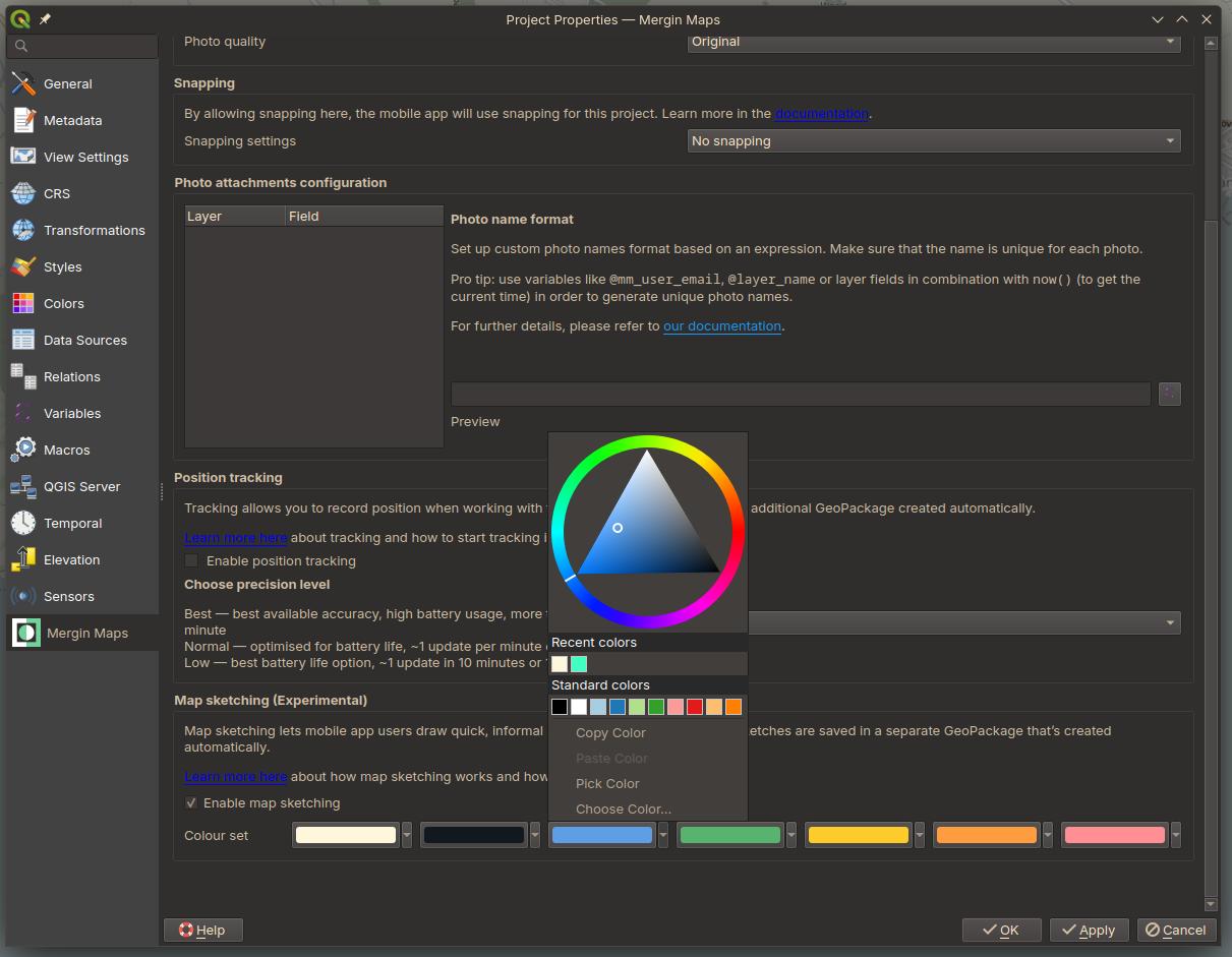
When you are finished editing the project, you can synchronise the changes to enable the feature for users in the mobile app.

Sketching in the app

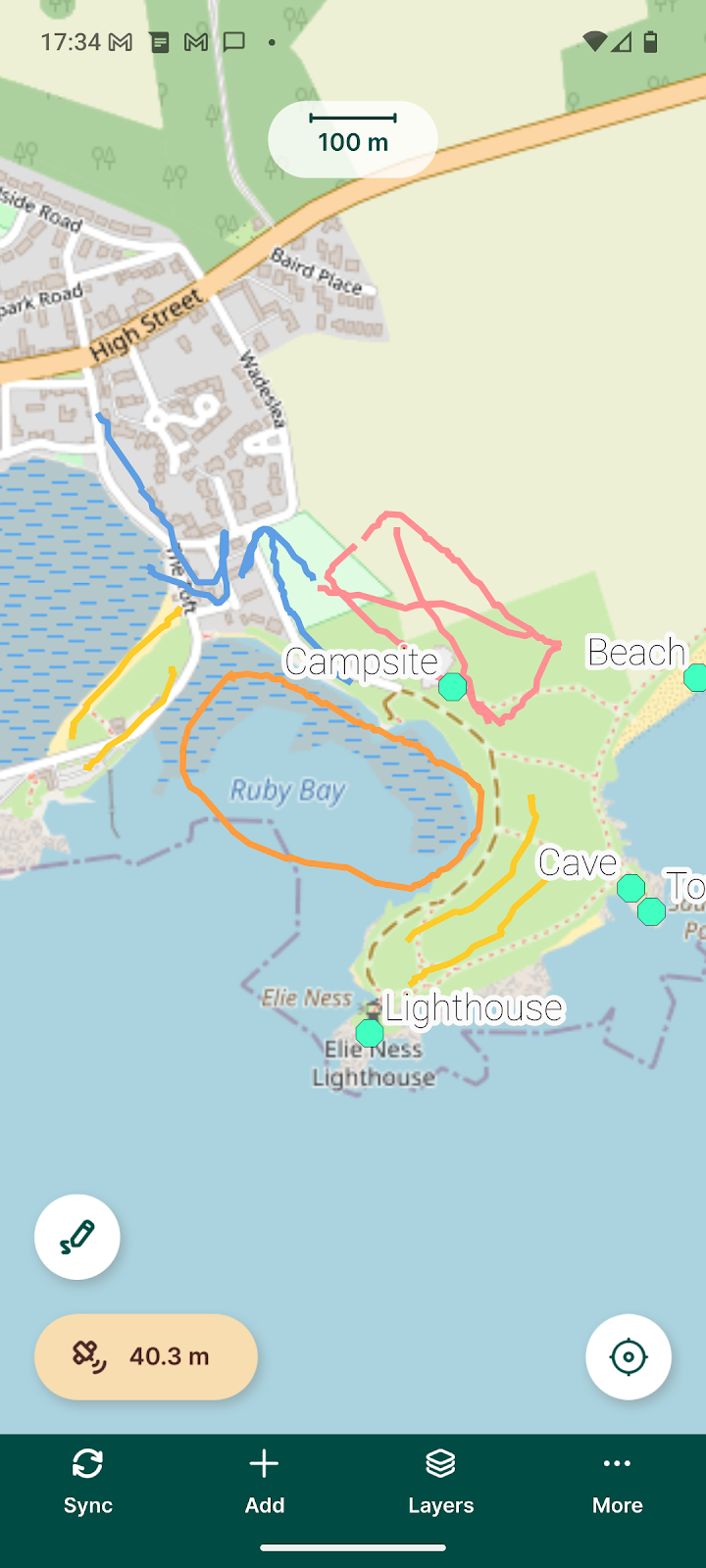
Once sketching has been enabled for the project, it is ready to use in the app. After users synchronise their projects, they will see a new pencil icon to activate sketching in the bottom left of the map view. They can then select one of the preset colours to begin drawing notes on the map. Sketching can either be done by using your fingers or a stylus for better control.

There are also ‘Undo’ and ‘Eraser’ buttons which either undo the previous action or erase a drawn feature by clicking it. 

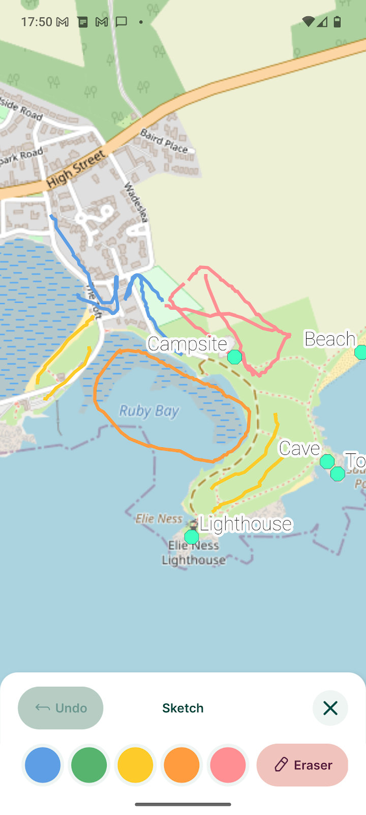
When you are finished sketching, just click on the green ‘X’ button to close the sketching window. The next time you synchronise your project, it will upload the notes to the sketching layer for others to see.

Getting even sketchier

We hope you enjoy the new sketching feature in Mergin Maps, but we have more plans for this feature coming soon. We are already developing a feature to allow users to sketch notes on photos taken with the app. Please give us any feedback on the new feature by joining our community Slack channel where you can also get support and keep up on the latest announcements regarding everything Mergin Maps. Also be sure to check out our Wishlist page where you can request and vote on new features that you’d like to see us add to the service. 

The map sketching feature was funded by KoBold Metals. If you want to streamline your desired feature, come and talk to us.

You might also like

Mergin Maps

Single Sign-On (SSO) is now available for Enterprise plans

June 30, 2025

partners

Camptocamp becomes first official Mergin Maps reseller

June 6, 2025

Mergin Maps

New API tools give you more user management options!

May 30, 2025

Mergin Maps

How to Conduct a Field Survey Using QGIS and Mergin Maps: A Complete Step-by-Step Guide

April 16, 2025

plugin

Great Scott! Mergin Maps Plugin has a time machine

March 19, 2025

Mergin Maps

Unlocking premium features of Mergin Maps for all

January 15, 2025

Mergin Maps

2024 - Year in review

December 20, 2024

Mergin Maps

Support tip: What to do if your project is too big

November 29, 2024

Mergin Maps

Mergin Maps now measures in taps

October 24, 2024

Mergin Maps

Announcing the first ever book about Mergin Maps from Locate Press

September 20, 2024

mobile

Support tip - How to make recording lines and polygons simple

August 30, 2024

Mergin Maps

5 best field data collection apps

July 17, 2024

Mergin Maps

Introducing Editor permissions - our most-requested feature!

June 20, 2024

Mergin Maps

We hope you’re enjoying the new experience!

May 31, 2024

QGIS

Support tip: Add SVG symbols to your QGIS project

May 2, 2024

Mergin Maps

Mergin Maps app is getting a fresh new look

March 28, 2024

Mergin Maps

QField vs. Mergin Maps - App Comparison

March 1, 2024

Mergin Maps

Hello from Mergin Maps!

February 13, 2024

plugin

Support tip: Downloading a previous version of your project

January 31, 2024

Mergin Maps

Mergin Maps 2023: our year in review

December 28, 2023

mobile

Mergin Maps is now faster and more stable than ever

November 15, 2023

plugin

Download tiles for offline background maps in five steps

October 30, 2023

partners

We've partnered with MarXact for high-precision surveying in Mergin Maps

October 27, 2023

event

Come see us at INTERGEO 2023 in Berlin

September 29, 2023

Mergin Maps

Mergin Maps Gets a Brand Refresh

September 27, 2023

Mergin Maps

We’ve added the ability to customise photo names in Mergin Maps!

August 31, 2023

mobile

You asked for it and we delivered… Position tracking in Mergin Maps!

August 22, 2023

Mergin Maps

Features wishlist - Help us help you!

July 27, 2023

Mergin Maps

Check out the Mergin Maps interview on App of the Day

May 4, 2023

event

Mergin Maps hope to see you at GeoBusiness London 2023

May 2, 2023

Mergin Maps

Worried about using open-source geospatial software for your business? Mergin Maps support is here for you!

April 28, 2023

Mergin Maps

Camptocamp partners with Mergin Maps to deliver open source GIS solutions

April 25, 2023

Mergin Maps

Subscription tiers are going to change

April 18, 2023

Mergin Maps

Mergin Maps Community and Enterprise Editions

March 31, 2023

Mergin Maps

Introducing Workspaces: Simplified Collaboration

January 31, 2023

Mergin Maps

Mergin Maps: a year in review (2022)

December 20, 2022

Mergin Maps

Mergin Maps in MapScaping podcast

December 15, 2022

plugin

View and track changes in QGIS

December 14, 2022

By clicking “Accept All Cookies”, you agree to the storing of cookies on your device to enhance site navigation, analyze site usage, and assist in our marketing efforts. View our Cookie Policy for more information. Deny cookies here.