Mergin Maps

Audit Logs and Web maps arrive in Enterprise Edition 2026.10.1 

Managing a bustling self-hosted server usually involves two things: keeping geospatial data running smoothly, and trying to figure out which ghost in the machine revoked a colleague's writing permissions at 4:58 PM on a Friday. With Enterprise Edition 2026.10.1, the phantom has an identity. Our new Audit Logs feature brings complete accountability to your admin panel, tracking permission changes, user logins, and project moves in plain sight. Rounding out the update, we’ve also introduced native Webmaps, robust OGC API feeds, and vital security improvements to keep your GIS infrastructure shipshape. 

Audit Logs

Managing multi-user Enterprise environments gets messy fast. Until now, self-hosted Mergin Maps admins lacked a central place to track workspace moves, permission tweaks, and logins. The new Audit Logs page solves this, giving administrators complete visibility to troubleshoot faster and strengthen server security. 

How it Works

The main product of the new audit logs feature is a page in the admin panel with a detailed view on who changed what on the server and when. Whenever an incident happens that requires well-informed troubleshooting by the administrator, they can open the page to acquire that information. 

A typical example is when an administrator receives a support ticket from one of the users that their role of writer was changed to reader in a project. The administrator can open the audit logs page, filter by the project.member.updated event and find the user whose role changed. By pressing on the entry, they can also see the user who performed the change, and act accordingly. In another case, the administrator is contacted by a user about trouble logging into their account. From the audit logs page, the admin can filter by the user who issued the ticket, see if indeed there is trouble with the login and the reason why. 

The new Audit logs page in the admin panel. Contains the filtering options, an ID toggle and sorting capabilities

‍

Audit logs record changes across three areas:

  • Projects, and more specifically creation, settings changes, deletion and restore, members, transfers, access requests, new versions, and map sharing and OGC API links.
  • Users, including logins, password changes and resets, account changes, locked accounts and admin panel access.
  • Workspaces, such as creation, settings changes, deletion and restore, members and invitations.

Browsing and downloading data is not logged. The full list of supported changes can be found in the documentation. 

It is also possible to filter entries by date, event type, who performed the action, the affected user, workspace or project. 
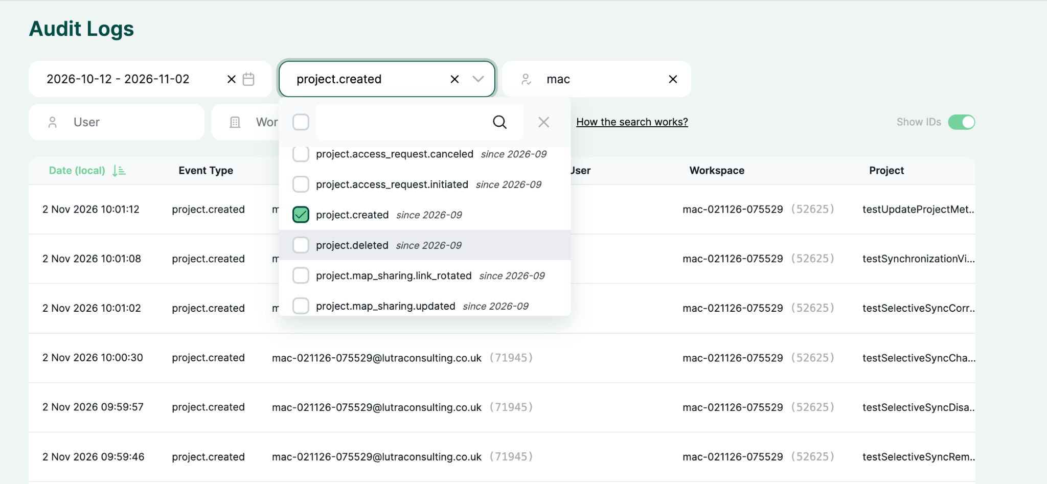
Filtering by created project in the new Audit logs page

Availability

The new Audit logs feature is included at no extra cost for self-hosted Mergin Maps Enterprise edition servers. The Audit logs contain all the logged history of their server from the moment the server is updated and the admins can adjust the retention period. More info on that can be found in the documentation. Logs are stored in the server’s PostgreSQL database, in a separate schema. For other storage options, contact sales.

‍

Other updates

Web maps updates

We consider web maps to be a core part of Mergin Maps, and we are excited to introduce them in the Enterprise Edition! With web maps enabled, you now have access to features such as:  

  • Share via URL: Anyone with the link can view the map, even without a Mergin Maps account.
  • Embedding: You can incorporate your maps in other websites or apps, using HTML embedding.
  • Web map applications: You can build custom apps with JavaScript.

All those features come in a redesigned interface, which also includes a fullscreen map with QGIS map themes, layer tree, custom basemaps and auto-refresh. 

Find out more about Web maps.

OGC API

Enterprise Edition now supports OGC API. Once you enable it, you can serve your project data directly to external GIS software, with no extra server hosting or setup needed. Both WMS and WFS services are read-only, so your original data stays safe while it is shared.

Find out more about OGC API. 

Other improvements

Other improvements include:

  • Security enhancements: Upgraded packages to fix security audit errors, preventing uploading invalid paths to the server, and more.
  • Other fixes and enhancements: Allowed resending workspace invitations, added “Last Signed In” information to the Members table in the dashboard, and more.

‍

Find out more about all the changes in our release note. 

‍

Next steps

If you’re ready to bring order to your server and put Audit Logs to work, it’s time to update. Enterprise Edition 2026.10.1 is available now, complete with early-access Webmap sharing, OGC API endpoints, and fresh Docker Hub images (give our support team a shout if you need access).

Head over to our 2026.10.x Migration Guide for everything you need to know about upgrading your self-hosted instance without the headache.

‍

You might also like

Mergin Maps

Mergin Maps best practices: From setup to fieldwork

September 16, 2026

Mergin Maps

A new direct way to connect Trimble receivers

September 3, 2026

Mergin Maps

Take your QGIS projects to the web: Now with map themes and JS customizations

August 27, 2026

Mergin Maps

Connect external GPS receivers via network (TCP/UDP)

July 27, 2026

Mergin Maps

Introducing early access: one-click OGC API support 

June 30, 2026

other

Best alternatives to ESRI ArcGIS Field Maps

May 8, 2026

Mergin Maps

From wishlist to app: Feature filtering is live

April 24, 2026

Mergin Maps

Support tip - using conditions to improve your Mergin Maps survey

March 26, 2026

Mergin Maps

The ecologist’s guide to offline GIS data collection and mobile mapping

March 6, 2026

Mergin Maps

Support tip - enhance your QGIS project with rule-based symbology

February 12, 2026

plugin

Plugin and API update brings simultaneous syncs

January 29, 2026

QGIS

How to import geotagged photos into QGIS for fieldwork mapping

January 23, 2026

Mergin Maps

Share maps via URL: now in early access

December 15, 2025

QGIS

How to collect GPS points for QGIS on Android with Mergin Maps

December 8, 2025

QGIS

How to use Mergin Maps to collaborate on QGIS projects

November 28, 2025

Mergin Maps

Support Tip: Using HTML to improve your Mergin Maps project

November 12, 2025

Mergin Maps

Photo sketching is now available in Mergin Maps

October 28, 2025

Mergin Maps

Best practices for user management in Mergin Maps

October 10, 2025

QGIS

Create professional survey reports using QGIS Print Layout after field data collection

September 15, 2025

QGIS

5 Essential QGIS Plugins for GIS Professionals

August 13, 2025

Mergin Maps

Mergin Maps gets sketchy

July 31, 2025

Mergin Maps

Single Sign-On (SSO) is now available for Enterprise plans

June 30, 2025

partners

Camptocamp becomes first official Mergin Maps reseller

June 6, 2025

Mergin Maps

New API tools give you more user management options!

May 30, 2025

Mergin Maps

How to conduct a field survey using QGIS and Mergin Maps: A complete step-by-step guide

April 16, 2025

plugin

Great Scott! Mergin Maps Plugin has a time machine

March 19, 2025

Mergin Maps

Unlocking premium features of Mergin Maps for all

January 15, 2025

Mergin Maps

2024 - Year in review

December 20, 2024

Mergin Maps

Support tip: What to do if your project is too big

November 29, 2024

Mergin Maps

Mergin Maps now measures in taps

October 24, 2024

Mergin Maps

Announcing the first ever book about Mergin Maps from Locate Press

September 20, 2024

mobile

Support tip - How to make recording lines and polygons simple

August 30, 2024

Mergin Maps

5 best field data collection apps

July 17, 2024

Mergin Maps

Introducing Editor permissions - our most-requested feature!

June 20, 2024

Mergin Maps

We hope you’re enjoying the new experience!

May 31, 2024

QGIS

Support tip: Add SVG symbols to your QGIS project

May 2, 2024

Mergin Maps

Mergin Maps app is getting a fresh new look

March 28, 2024

Mergin Maps

QField vs. Mergin Maps - App Comparison

March 1, 2024

Mergin Maps

Hello from Mergin Maps!

February 13, 2024

plugin

Support tip: Downloading a previous version of your project

January 31, 2024

Mergin Maps

Mergin Maps 2023: our year in review

December 28, 2023

mobile

Mergin Maps is now faster and more stable than ever

November 15, 2023

plugin

Download tiles for offline background maps in five steps

October 30, 2023

partners

We've partnered with MarXact for high-precision surveying in Mergin Maps

October 27, 2023

event

Come see us at INTERGEO 2023 in Berlin

September 29, 2023

Mergin Maps

Mergin Maps Gets a Brand Refresh

September 27, 2023

Mergin Maps

We’ve added the ability to customise photo names in Mergin Maps!

August 31, 2023

mobile

You asked for it and we delivered… Position tracking in Mergin Maps!

August 22, 2023

Mergin Maps

Features wishlist - Help us help you!

July 27, 2023

Mergin Maps

Check out the Mergin Maps interview on App of the Day

May 4, 2023

event

Mergin Maps hope to see you at GeoBusiness London 2023

May 2, 2023

Mergin Maps

Worried about using open-source geospatial software for your business? Mergin Maps support is here for you!

April 28, 2023

Mergin Maps

Camptocamp partners with Mergin Maps to deliver open source GIS solutions

April 25, 2023

Mergin Maps

Subscription tiers are going to change

April 18, 2023

Mergin Maps

Mergin Maps Community and Enterprise Editions

March 31, 2023

Mergin Maps

Introducing Workspaces: Simplified Collaboration

January 31, 2023

Mergin Maps

Mergin Maps: a year in review (2022)

December 20, 2022

Mergin Maps

Mergin Maps in MapScaping podcast

December 15, 2022

plugin

View and track changes in QGIS

December 14, 2022

By clicking “Accept All Cookies”, you agree to the storing of cookies on your device to enhance site navigation, analyze site usage, and assist in our marketing efforts. View our Cookie Policy for more information. Deny cookies here.