
Capturing high-precision field data just got a whole lot easier and far more reliable. While connecting to external GNSS receivers wasn't new for Mergin Maps, iOS users were previously stuck relying on workaround mock locations with limited data, while receivers using TCP/UDP connections (such as EOS) lacked a direct path into the app.
All of that is overcome with our latest release! We’ve introduced a direct TCP/UDP connection to external GNSS receivers via IP address and port number, which we call the Network position provider support. iOS users can now connect directly to external receivers over the network, while Android users have the choice to connect either via network or Bluetooth. This means iOS users can finally capture high-precision data and read advanced positioning information like accuracy, HDOP, satellite details and more.
How it works
If your GNSS receiver supports TCP/UDP connections, Mergin Maps can now establish a direct connection to it. Simply fill in the device's IP address and port number, and the app will automatically establish the connection, distinguishing between TCP and UDP behind the scenes without any extra setup required. Once connected, your Mergin Maps project will automatically use the high-precision positioning data provided by your external receiver instead of your mobile phone's built-in GNSS.
Follow this step-by-step setup to test the new feature for yourself:
Step 0: Follow the instructions from your GNSS receiver manufacturer to connect the receiver to your mobile device.
Step 1: In the app settings, go to Manage GNSS receivers and tap on the “Connect new receiver” button. (Note: On Android devices, you will be prompted to choose between Bluetooth and Network connection, so select Network.)

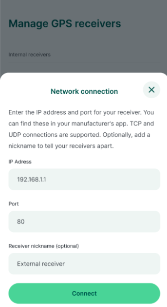
Step 2: Fill in the IP address and port number of the device (refer to the device's proprietary app or user manual for these details). Optionally, add a nickname for easy identification later. Press “Connect”.
Step 3: Mergin Maps will establish a connection with the receiver in the background. Once connected, a confirmation message will let you know the connection was successful.
Step 4: You are all set up! You can now start using the app with your external GNSS provider for your specific field use cases.

For more details and technical specs about network position, check out our documentation.
Ready to get started?
To start mapping with direct network GNSS support, all you need is an external GNSS receiver and the latest version 2026.3.0 of the Mergin Maps app.
A big thank you to our partners at EOS Positioning Systems for helping develop and refine this functionality!